|
Located off Firehall Rd. at the North end of the village of Providence
Bay (by the arena), this is the property line between Lots 3 and 4,
running from Firehall Rd. down to Lake Huron. The 2 km. walk takes
you through thick cedar bush, open meadows, rare alvars rock outcrops,
wildflowers, and down to the private and secluded beach at Lake Huron.
Keep an eye out for wildlife (hawks, turkey vultures, owls, grouse, deer,
field mice, rare red squirrels, raccoons, foxes, and rabbits).
Often, you will find large rocks recently overturned by large animals
(ie. bears) looking for a meal. The walk will take you 1 to 2 hrs.
This verdant 100 acre park is located on New England Road, a side road
off Hwy. 6, mid-way between Manitowaning and South Baymouth. The park,
almost 3 km. along the New England Road, features hiking trails based on
ancient logging paths. Hardwood bush with some huge trees. The
walk takes about 1.5 hrs.
This trail is in Sheguiandah, accessible from the East side of Hwy. 6,
just across from Corcoran's Motel. Approx. 2 km. in length and a
relatively easy hike, the trail nevertheless provides two quite
spectacular views of Bass Lake and the North Channel. The lookouts
are on Quartzite outcrops. The walk takes 1.5 hrs.
Sheguiandah is also the home of Orr's Mountain Hiking Trail. The
3.5 km. trail begins in the village's North end, 100 meters up Orr's Side
Rd., just off Hwy. 6. There are three distinct trails on Orr's
Mountain, offering fine views of Sheguiandah Bay, Bass Lake, and two
spectacular lookouts. The walk takes 2 hrs.


Located 18 km. West of Little Current at the junction of Hwy. 540 and
Bidwell Rd. is the famous Cup and Saucer Trail. This is the
Manitoulin Extension of the Niagara Escarpment, with 70 meter cliffs, over
2 km. long. There are 12 km. of hiking trails through the hardwood
bush, as well as 2 km. adventure trail. This is one of the most
popular trails in Ontario. With the numerous paths, you can choose
the one best suited to your time available (from 15 min. to 4 hrs.), and
degree of difficulty desired.
Located on M'Chigeeng Native Reserve land, the trail starts behind the
ballpark, off Hwy. 551, just South of Hwy. 540. Recently doubled in
length, M'Chigeeng includes two trails; one along the bottom of the bluff,
and the other going to the very top. The Bear Caves and Fossil Rock
Point are two spots of special interest. The top of the bluff offers
outstanding views of the North Channel. The aboriginals regard this
as a special place for spiritual cleansing. The walk takes 2 to 3 hrs.
Right off Mindemoya's main street (Hwy. 542), Wagg's Woods is located
almost directly across the street from the Municipal Office and Library.
This peaceful walk features maple, basswood, birch, and ash in a park-like
setting. Moss climbs the cliffs which are part of the Niagara
Escarpment. Watch for 15 different species of ferns. The walk
will take 1 to 2 hrs.

This trail is located on Hwy. 540 at the entrance to Kagawong. A
picnic area is at the top of the falls,, with a path that leads down to
the base of the falls. There is a trail on both sides of the river
valley. Bring your bathing suit, and take a dip in the pool at the base of
the falls. Once you reach the town at the mouth of the river, take a
walking tour of this small village, museum, and art galleries.
Misery Bay Provincial Nature Reserve is an 860 hectare provincial park
on the South shore of Manitoulin Island. 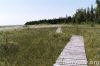 Located 10 minutes drive
West of Evansville. There are two trails about 5 km. and 4 km. which
feature mixed woodland, old beach ridges, and
rare alvars
(flat limestone bedrock with no soil). A visitor centre/interpretive
centre provides information on the unique and rare aspects of this park.
The walk will take about 2 to 4 hrs. Located 10 minutes drive
West of Evansville. There are two trails about 5 km. and 4 km. which
feature mixed woodland, old beach ridges, and
rare alvars
(flat limestone bedrock with no soil). A visitor centre/interpretive
centre provides information on the unique and rare aspects of this park.
The walk will take about 2 to 4 hrs.
The picture shows the Misery Bay boardwalk across the wetlands.
North of Silver Water, off Hwy. 540, the Sheshegwaning First Nations
have developed 20 km. of trails. You can choose between many
sections of trails, some offering wonderful views of the North Channel.
There are facilities for camping and picnicking. Trail maps are
available from the Band Office, or at the Gas/Convenience store at the
trail head. This walk takes between 3 to 6 hrs.
Located at the lighthouse near Meldrum Bay are several short trails
that follow the craggy shoreline over flat limestone ledges, around
enormous boulders, and through rock fissures. Wildflowers and birds
abound, and the rails offer fine views of Lake Huron. This is an
excellent trail for the afternoon, then stay for a fantastic sunset over
Clapperton Island to the West. Allow 1 to 2 hours for this
challenging and exciting hike.
|


