The Beach at & near the Cottage
|

Providence Bay has the largest sand beach on Manitoulin; more than 1.5 km.
long. This is just 2 km. from the BBay cottage.
|
This is an aerial photo of Providence Bay showing the large sand
public beach, the children's beach playground equipment, the Interpretation
Centre building, the Boardwalk along the edge of the Bay, the Mindemoya
River, and looking North up the main street of Providence Bay
On the right side of the photo, the beach is interrupted by the Mindemoya
River. This river is about 1 to 3 ft. deep where it enters Lake Huron,
but is usually 5 degrees warmer. This makes an excellent area for small
children to play in the water and stay warmer.
Mindemoya River is a salmon stream, and makes for excellent fishing.
|

|
Close-up on the sandy
beach and Providence Bay. The entire bay is 100% sand; fine and
clean. The water slowly gets deeper as you go out; avoiding any sudden
drop-off.
Providence Bay has one of the safest beaches for small children.
Consistently clean, purely Canadian water.
|

|
The public beach in town has the largest sand
beach on Manitoulin Island (over 1.5 km. long). The protected
waters in the Bay can get quite warm in summer. The beach at Providence
Bay is similar to Canaterra Park in Sarnia, the Pinery, or Wasaga Beach,
etc.
Here, we are looking South onto Providence Bay (just 2 km East of Black's
Bay).
|

|
Looking North on the public beach at
Providence Bay (2 km. East of Black's Bay), we find a future structural
engineer contemplating the angle of repose for wet sand as a castle
construction material. The rear part of the beach has large sand dunes
similar to Pinery Provincial Park.
There is a boardwalk from town all along the shore, almost as far as
the marina at the far end of the bay.
|

|
Looking South over Providence Bay, we can see the young swingers enjoying the public beach
playground equipment. The Town public beach enjoys the best part of
Providence Bay.
There is a full set of swings, climbers, and a Nature Interpretation
Centre at the start of the boardwalk.
|

|
View of the Lake Huron waterfront from the
2nd floor deck of the cottage. With a good pair of binoculars, you can
see the sportsmen pulling their salmon on-board.
The water starts shallow, then gets deep very slowly, so it's ideal for
young children.
The second floor deck is a great place for a quiet sit while staying in
tune with the outdoor action.
There are two patio chairs and a small table here; an excellent place to
have your morning coffee.
|
 |
Click on the picture for a full-sized view of
BBay's waterfront, as seen from the roof of the cottage. Everything you
see here is private beach for your exclusive enjoyment during your stay at
BBay's waterfront cottage. |

|
The beach at Black's Bay during sunset,
looking South-West. You can just barely see the 45 ft. tower for the
wind generator (vertical, thin black line from ground into the clouds).
|
 |
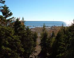
View of BBay's beach from the
cottage's deck, looking through the trees. |

|
Picture was taken from the
East side of Black's Bay, looking due West at the summer sunset.
You had full peace & quiet; all alone on this beach for as far as you can
see (2 km. to the West, 4 km. to the East, along the shore).
The only action was a family of loons swimming by.
That's what we call
private.
Along the shore, 2 km. to the East (at the town of Providence Bay), there
is a sandy beach with a few hundred people sunning & swimming (if you want
crowds).
|

|
Looking Due South at Beach and Lake Huron
(one of the Great Lakes between Michigan USA and Ontario Canada. We
have over 2300 feet of private beach here.
|

|
Composite of 3 pictures to give panoramic
view of BBay's waterfront.
Click on the image to see the whole view in full size, living colour
You have a full 2,300 ft. of shoreline (about 1,500 ft. of it is shown
here) to enjoy and explore in privacy. Panoramic composite picture of
BBay's beach.This shows the flat limestone alvars (rare ecosystem
recognized by UN Biosphere), and all types of rocks (volcanic,
sedimentary, metamorphic, conglomerates, etc.) with numerous fossils to be
found.
|

|
Looking Southwest at the waterfront on Lake
Huron from Black's Bay. The very gentle slope eases parent's minds
about youngster trying out new swimming or fishing skills, safely near the
shore. Yes, you can see the bottom in this water. It's that clean.
In town, at the Government dock, the water is approx. 25 ft. deep.
You can watch the fish swimming by & see the bottom, even there.
|


